DunsField Farms, Imashayi, Ogun State
Transforming Maize Farming with Drone-Based Plant Counting
By using high-resolution drones and AI analysis, we provided a precise plant count for a 5-hectare maize farm, revealing a significant under-population of 20,484 plants/ha and delivering an immediate action plan to mitigate yield loss
The Problem
The Problem: The High Cost of "Not Knowing"
Every planting season is an investment aimed at a single goal: a bountiful harvest. However, for many commercial farms, success is often left to chance, hindered by a critical lack of early, accurate data. Without a precise understanding of plant germination and survival, farmers cannot make timely interventions, leading to significant, preventable yield loss.
In May 2025, DunsField Farms faced this exact challenge. They knew some areas of their 6-hectare maize farm were underperforming, but they lacked the tools to quantify the problem across the entire field. Manual counting was impractical, and by the time emergence issues were visible by eye, the optimal window for corrective action, like replanting, was often already closing.
They needed to move from guesswork to data-driven certainty. They needed to know their exact plant population to secure their investment.
Our Solution
Precision Agriculture Using Drones and AI
To provide DunsField Farms with the actionable intelligence they required, we deployed our systematic, three-step aerial analysis solution.
Step 1: High-Resolution Data Capture
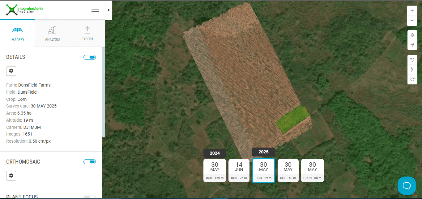
We conducted a drone flight at a low altitude of 20 meters above ground level. This captured ultra-high-resolution imagery with a Ground Sampling Distance (GSD) of just 0.5 cm/pixel—detailed enough to distinguish individual 3-week-old maize plants from the air. These images were then stitched together to create a seamless, high-resolution orthomosaic map of the entire 6-hectare farm.
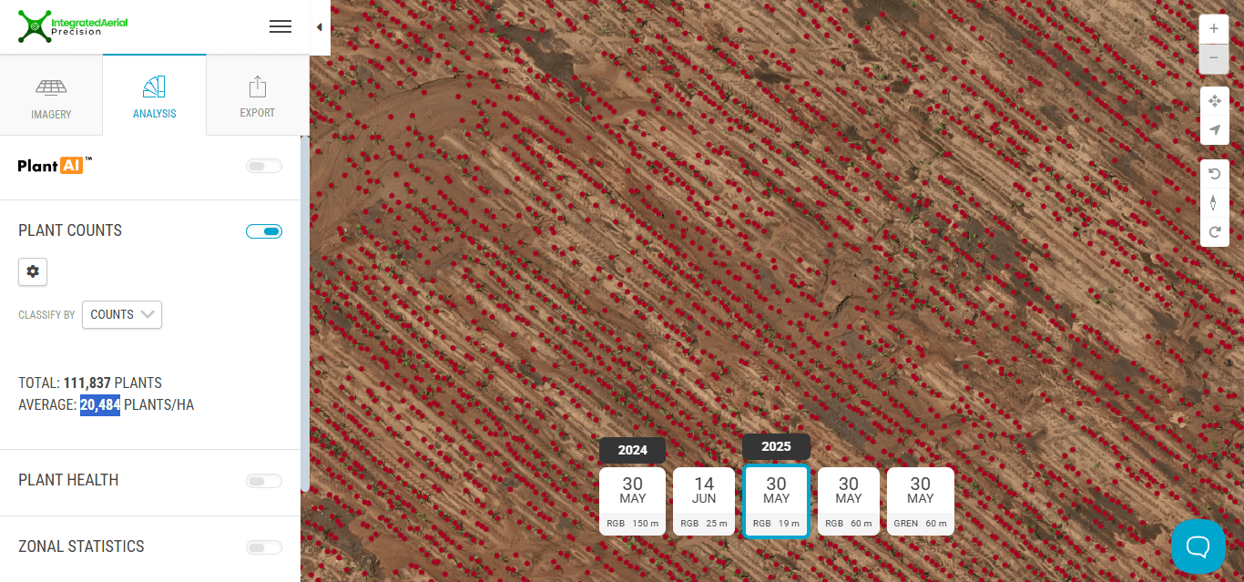
Step 2: AI-Powered Plant Detection
The orthomosaic map was fed into our AI-powered analysis software. The "brain" of our operation, the AI model, processed the entire field in minutes, a task that would take days of manual labor. It performed several key actions:
- Identified Individual Plants: The algorithm detected the unique canopy shape, pixel signature, and spacing of each maize plant.
- Filtered Out Noise: It was trained to distinguish between maize, weeds, and other non-plant objects, ensuring an accurate count.
- Eliminated Human Error: By applying consistent detection rules across the entire field, the AI removed the fatigue, bias, and miscounts inherent in manual methods.
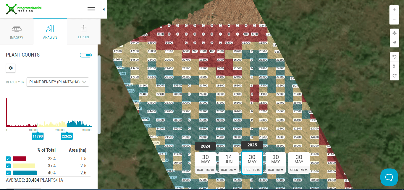
Step 3: Generating Actionable Intelligence
The final output was a clear, intuitive, color-coded Plant Density Map. This visual report instantly highlighted problem areas, showing precisely where plant populations were healthy, where they were thin, and where they had failed completely.
The Results
6.53
hectares mapped in 30 Minutes
97%
Plant Count Accuracy compared to manual counting
40%
Identified Under-Planted Area for Replanting
35%
Potential Yield loss Saved
From Data to Decisive Action
Our analysis provided DunsField Farms with immediate, game-changing insights that transformed their farm management strategy.
1. Data-Driven Clarity: A Shocking Discovery
The analysis revealed a stark reality: the farm had an average plant population of only 20,484 plants per hectare. This was less than half of the 55,000–80,000 plants/ha required for an optimal yield. The farmer now had a precise, undeniable metric that quantified their production gap.
We needed to have an accurate estimate of our farm yield at different stages of growth, so we could replant early. Our old methods involved us monitoring per hectare, which was slow and ineffective, but with drones, the process became faster.
2. Comprehensive Root Cause Analysis
The density map and aerial imagery allowed us to diagnose the likely causes of the poor plant population, including:
- Mechanical Issues: Bare strips suggested planter skips or uneven seed depth.
- Soil Problems: Patches of poor emergence correlated with compacted or waterlogged soil.
- Pest & Animal Damage: Random missing plants in otherwise healthy rows pointed to pest activity.
- Chemical Damage: Sharp-edged bare areas indicated potential herbicide or fertilizer burn.
3. An Immediate, Targeted Action Plan
Armed with this data, we provided the farm with a clear, strategic action plan:
- Targeted Replanting: Immediately spot-replant in areas identified by the map as having less than 70% of the target stand.
- Pest Scouting: Focus scouting efforts on the specific damage zones.
- Equipment Recalibration: Adjust planting equipment before replanting to prevent recurrence.
- Long-Term Soil Improvement: Plan for soil amendments and improved drainage in problematic zones for the next season.
By replacing ambiguity with accuracy, we empowered DunsField Farms to stop reacting to problems and start strategically managing their fields for higher yields and reduced waste.
Ready to unlock the true potential of your farm? Contact us today for a consultation.
